The report written by the Town's planning staff that went before councillors on 28 November 2016 contained key information which was known at the time by the Director of Planning to be bogus and misleading.
The report did not challenge the stated FSI (Floor Space Index) of the Clock Tower (2.9) when it was known to be much higher (4.27). Developments in the historic downtown are supposed to have an FSI of 1.0 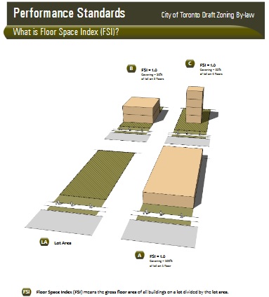
The FSI is calculated by dividing the gross floor area by the lot size. Forrest's own Planning Rationale Report says the gross floor area of his proposed development is 11,059 sq m and the lot area is 2,655 sq m. This gives an FSI of 4.279 yet the figure 2.9 appears throughout Forrest's documentation.
Forrest brazenly added the underground car parking area (1,183 sq m) to the surface lot (2,655 sq m) and came up with 3,838 sq m. To calculate his bogus FSI he divided the Gross Floor Area 11,059 by 3,838 to get an FSI of 2.88 which is the figure (2.9) he has been is relying on. The public was never told about this subterfuge.
Forrest used Town owned land under Market Square, earmarked for the Clock Tower’s underground car park, to bring down the development’s FSI.
At the end of the meeting on 28 November 2016, Van Trappist, reading from a prepared script, said:
"...whether we agree with the recommendations or not this is a very comprehensive report that has been thoroughly examined."
He went on to ask Rick Nethery to comment on the FSI issue which had been repeatedly raised by a member of the public, Siegfried Wall, who told the Statutory Public meeting on 9 May 2016 that underground parking space, owned by the Town not the developer, was being used in the calculations to massage the FSI downwards.
Nethery told Van Trappist:
"There's no question that what Mr. Wall was saying is that we're looking at an FSI that's above what is currently in the documents. We don't dispute that. That is a question of whether or not if Council were to approve it they would be so approving with that in mind.
I guess there is some differences based on whether or not you're looking at a net and a gross. There is some question of whether or not we're going underneath the ground for parking versus completely within the area currently owned by the Clock Tower property. (My underlining for emphasis.)
Is it not truly astonishing that a Planning report with recommendations being put before councillors for decision, knowingly contained a misleading FSI? And Nethery would have known that the FSI is calculated using the gross floor area. The "comprehensive" report contained no comment or explanation of the developer's 2.9 FSI. It was accepted uncritically. 
This begs the question:
When did (a) Van Trappist and (b) councillors first learn that the FSI was being manipulated in this way?
When did the developer's heritage consultants, Goldsmith Borgal, and the Town's peer reviewer, ERA Architects, learn that the Clock Tower's FSI had been calculated by using underground land in Town ownership? And what was their reaction? Did they appreciate that this would have a knock on effect on the built form of the development, allowing it to be much bigger in scale and mass than otherwise would be the case? Was this manipulation - which had been concealed from the public - considered legitimate and par for the course?
Answers to these questions will eventually come out - at the OMB Hearing or, hopefully, beforehand.
This email address is being protected from spambots. You need JavaScript enabled to view it.
Background: The last time a report from the Town's Planning staff mentioned an FSI of over 4 was in November 2013 when Forrest's (then) development had an FSI of 4.25. (Development and Infrastructure Services/Planning and Building Services Report 2013/55).
An applicant can, of course, apply for a zoning by-law amendment covering land he or she doesn't own. This is precisely what Forrest has done. But, even if approved, the developer must secure the rights over that land by buying it or by an easement or some other legal device.
In May last year, Forrest's Planning Rationale Report told us the Historic Downtown Centre Zone (UC-D1) permitted up to 80 residential units per net hectare and up to and including a 1.0 FSI. Yet Forrest wanted a residential density of 430 units per net hectare and an FSI of 2.9. He tried to justify this humungous departure from the Town standard in this way:
"It must be recognised that the Proposal does not have the benefit of additional land for surface parking and landscaping. The units per hectare value appears much higher due to the building footprint mirroring the property line and as such this condition must be taken into consideration when considering the appropriateness of the density. (my emphasis)
But why must this be taken into consideration?
There is no reason whatsoever why the Town standards should be set aside to accommodate a giant out-of-place development which is simply too big for the land on which it sits.